
Conservation
Exploring the Sears Point petroglyph site
“Hmm. Are you sure it’s out here?” she asked.
To be honest, it didn’t look very promising, at least not yet.
“Yep, it’s up ahead a few more miles,” I responded, in a tone that likely overstated my own confidence.
We had already driven an hour from Phoenix to Gila Bend, then another hour west along Interstate 8, then turned off at an exit to seemingly nowhere, jogged back east a mile along the access road, then turned north on an unremarkable dirt road impossibly named Avenue 76½ E. Along this rough-at-times road, we had passed two desert squatter communities, an out-of-place boat shipwrecked on the top of a small hill, and miles of seemingly barren desert.
Some skepticism was probably to be expected. After all, I hadn't exactly explained where we were going; I had just said that we'd find some rock art when we got there.
As it turns out, we were indeed on the correct road. A few miles further ahead was the Sears Point petroglyph site, an array of prehistoric and historic petroglyphs carved into a basalt ridge overlooking the floodplain of the once mighty Gila River. This is BLM land, a site well known by those who hunt rock art, but not a destination where you’ll find many tourists.
Finally, the road crested a small ridge, dipped towards the dry riverbed in the distance, and we could see our destination ahead. Ribbons of sandy driving routes spiderwebbed around tamarisk and mesquite clumps that dotted the lowland. I was glad to have my Subaru as we sloshed through deep pockets of sand and gravel, maintaining enough speed around the corners to avoid getting stuck. And just like that, we arrived at a patch of dirt sporting two informational kiosks and some carsonite signs indicating the road's end. We parked, stepped out of the subie, and immediately scanned the butte for the first sign of rock art.
"There's some over there," I said, nearly in code, and pointed towards a prominent panel gazing down upon us.
We grabbed some cold water from the cooler, donned our daypacks, and scrambled up towards the first panel with cameras in hand. And so began our rather impromptu visit to Sears Point.
The Sears Point petroglyph site
Archaeologists consider Sears Point to be one of the most significant rock art sites in the Southwest. In addition to more than 2,000 rock art panels incorporating nearly 10,000 petroglyph elements, the area contains a number of geoglyphs and other archaeological and historical features.
Simply put, there's a lot to see out here. And you'll need to do some exploring to see it.
Sears Point is just one of several other similar sites along the Gila River, including Quail Point, Hummingbird Point, and Oatman Point just a bit upstream. The only site signed from the interstate is Painted Rock, a now-defunct state park that's since reverted to BLM management. I won't get into what you'll find at each of these sites, how to get to them, or what makes them special, but a quick google search will answer most questions one would have.
It's important to note that while Sears Point is a named archaeological district, and is listed on the National Register of Historic Places, and is managed as an Area of Critical Environmental Concern by BLM, sadly none of these adds sufficient protection for this site or its neighboring ones.
The campaign to protect the Great Bend of the Gila
As a result, several organizations—led by Archaeology Southwest and the National Trust for Historic Preservation—have been campaigning to protect Sears Point and other important archaeological and historical sites upstream as the Great Bend of the Gila National Monument. It's a good idea and the cultural resources here are definitely worthy of such a designation.
The short video below explains a bit more about the cultural heritage this campaign seeks to protect.
Some tips if you plan on visiting
- You'll want an AWD or 4WD vehicle to drive to the parking area, though don't attempt it if it's rained recently. You could probably make the drive with a 2WD high clearance vehicle if you stopped short of the deepest sand, which starts around here, roughly a mile from the main petroglyph panels. Either way, be prepared to extricate yourself if you get stuck no matter what you're driving.
- Don't go in the summer heat, and be prepared with water and shade. You'll spend your entire visit scrambling over rocks while the sun beats relentlessly down on you, so please act accordingly. If it's warm out, you might want to consider gloves to protect your hands from hot rocks.
- If you don't have much time, check out the rock art panels near the top of the butte to the right. The largest panels and most easily accessible glyphs are found in that area, which will require some scrambling to get up to the faint trail that connects them. If you can, spend some time exploring the entire area, including the tops of the basalt mesas—there are thousands of petroglyphs, geoglyphs, rock alignments, and other artifacts in walking distance of your car. Stay alert to your surroundings and bring a gps to help you find your way back.
- Photographing sometimes faint petroglyphs on shiny basalt in the glaring sun can be a challenge, so keep this in mind as you plan your arrival and departure times. A circular polarizing filter can also be helpful in reducing shine and helping the rock art stand out better. An umbrella can both help keep you cool and shade smaller glyphs for better photographs. I wish I had considered these things before my visit.
- Practice Leave No Trace principles, and don't touch the petroglyphs or do anything else that might impact the site. Once damaged, we can never get these resources back.
- Want to learn more about lesser-known archaeological sites the public hasn't ever heard of? Here's the very best way to do that.
- Do some research before you go, especially on other nearby sites, if you'd like to make a longer day out of it. There are many accessible places to explore in the surrounding area and within the Great Bend of the Gila proposal area.

How to get there
From Gila Bend, Arizona, drive west on I-8 towards Yuma for roughly 30 mins to exit 78, Spot Road. At the end of the off ramp, turn north and then right on the frontage road. Head back east for about 1 mile to Avenue 76½E, then go north along the dirt road for about 7 miles. When you hit the sandy wash, stay on the most used route and aim for the low buttes to the west. You'll find a small dirt parking area and two kiosks; park here and explore the area on foot.
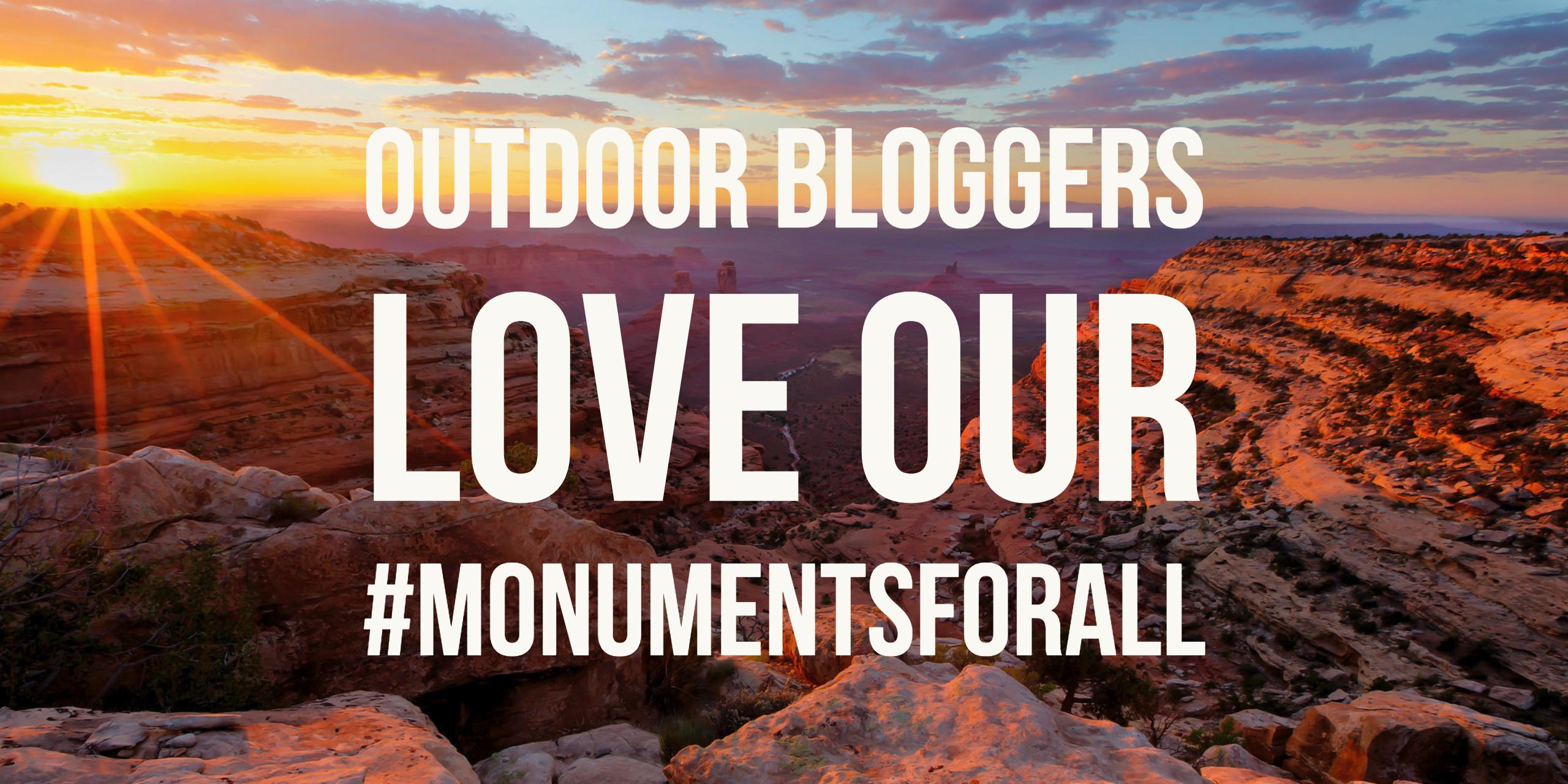
A 'Monumental' Day of Blogging
Today, nearly 30 outdoor bloggers came together to publish posts in support of our national monuments on the 111th anniversary of the Antiquities Act. We called it 'A Monumental Day of Blogging' and ask readers to defend #MonumentsForAll by submitting a public comment during the national monuments review.
Here's what we wrote:
- Deeply Personal—Why I Care About National Monuments - Just Get Out More
- Five Reasons to Love National Monuments - Nightborn Travel
- A Monumental Fight - AZ Day Hiker
- Rio Grande del Norte National Monument - Nature Tech Family
- Pro Tips: Tommy Caldwell Talks Public Lands - Little Grunts
- In the Heart of the Creek - Mike Off the Map
- Dear Mr President - The Zesty Traveler
- A Monumental Day of Blogging - Parks and Points
- A Monumental Day - West Coast Hiker Girl
- Hands Off Our National Monuments - Campfire Guy
- Celebrating National Monuments For All of Us - Val in Real Life
- Why You Should Be Championing #MonumentsForAll - Inner Compass
- National Monuments: The Bears Ears Debate and How You Can Help - Sun Kissed Hiker
- What is a National Monument & Why Should You Care? - Bearfoot Theory
- Speak Out For Our National Monuments Under Review - Terra Galleria
- Dear Secretary Zinke - Wilderness Within Her
- National Monuments, Public Lands & Wilderness - Southwest Dude
- Public Comment on the National Monument Review - Modern Hiker
- Hikes Across America's Monumental Day of Blogging - Hikes Across America
- New York National Monuments: What Are They? - Backcountry Petite
- Monuments For All—Help Save Our National Monuments - G Who Travels
- My National Monuments Public Comment & How You Can Submit Your Own - Explore With Heather
- Two Monumental Reasons To Fight: Grand-Staircase Escalante & Bears Ears - The Modern Outdoors
- A Monumental Day For Our Nation - A Gray(t) Adventure
- The Antiquities Act: A Monumental Success - Illuminations from the Attic
- 4 Lesser Known National Monuments and Historic Sites of Arizona - Hiking the Trail
Thank you to everyone who submitted comments during the comment period. Even though we were largely ignored by Sec Zinke in his attack on Bears Ears and Grand Staircase-Escalante, the remaining national monuments have been spared—for now, at least.

Deeply Personal: Why I Care About National Monuments
Thank you to everyone who submitted a public comment by the deadline!
I've struggled for days to write this post. But nothing I type seems remotely adequate.
Some drafts have been too argumentative. Or too wonky. Others have been downright angry. One was rather melancholy, a sad ode to losing the places you care most about. I'm stumped—there's really no way to say all that needs to be said. I guess I should start with this simple sentence:
National Monuments are deeply personal to me.
Over the last two decades, I've visited most of the places that term has ever graced—from the very first to be designated, Devils Tower, to one of the last, Bears Ears. I've backpacked in National Monuments that have been expanded and recast as crown-jewel National Parks, and hiked in National Monuments that have lost their protected status entirely. I've camped in obscure national monuments you've never heard of, and navigated through crowds of tourists to gaze upon the most famous of vistas. I haven't been to all of them—not quite yet—but I will. I've been inspired by too many to ever stop.
But this post really isn't about any of those experiences.
Nor will this post argue policy, or point out the infuriating inaccuracies and bald-faced lies that we've heard from monument opponents. It won't detail the troubled legality of Trump's national monument review, or recount why the whole thing has been an utter sham, or explain the economic value of protected lands to rural communities. I won't lament the short-sightedness of this administration or the lasting scars they can cause. I could refute for hours the arguments proffered by opponents, dazzle you with charts and maps, or spellbind you with the words of those inspired by these treasured places. I could stir your very soul with photographs and video.
Instead, I'll share a few glimmers of what I saw while working on national monuments over the last 12 years—the personal side of it. The full tale is, as you'd imagine, far too long to recount here today, and so is the list of characters involved. This will be but a brief glimpse into that world.
When I see national monuments, I don't just see amazing landscapes that protect our natural and cultural heritage. Because of my involvement over the years, I can't help but see several layers of story deeper. I see the countless people that help make these places even more special than they already are—that make the national monument designation actually mean something.
I see a middle-age woman who fell in love with a single vista, and left her man and corporate job and happy life in the city in order to see that view every night. An unexpected community leader, she's now involved in everything of note in her tiny gateway community, including personally financing the creation of a volunteer friends group she runs for the adjacent public lands she cares so much about.
I see a retired man who loves exploring, who spends countless weekends traipsing across wind-whipped plateaus in search of pottery sherds and rock art—making a hobby out of expanding our knowledge of the area while populating the database that's studied by land managers and archaeologists.
I see a government bureaucrat who still remembers the first time he stepped foot in his favorite national monument—two decades before it became one—and couldn't stop smiling at the scene before him. He endures the tedious parts of his job because of memories like that one. And that tedious work, even when I don't agree with each of his decisions, brings the promise of the national monument closer to fruition.
I see a graduate student, lending her newfound knowledge and seemingly boundless energy to the board of directors of the national monument's volunteer friends group. She stumbled into involvement with the group last year, and now spends her Tuesday nights in meetings and her treasured Saturdays—her only day off—coordinating various monitoring and outreach projects.
I see a shy man, who inherently avoids conflict and any remotely political discussion, sitting at his computer in the dim light of his living room. He's carefully outlining a powerful guest editorial that will be published in the city's newspaper later that week. Secretly terrified at taking such a public stand on a controversial issue, he pushes on because he believes in the cause at hand. He owes it to his two small grandchildren.
I see the young mother of a toddler, missing bathtime once again so she can sit in the dingy conference room to plot with her colleagues how to recruit more volunteers for next month's restoration project. She'll return home, put her daughter to sleep, and spend the next few hours making good on the volunteer tasks she took on during that meeting.
I see a small group of three volunteers practicing soliciting each other for a donation during a fundraising training session, trying to get comfortable with the act of asking for money for a big project they're involved in. It feels awkward and uncomfortable and nerve-wracking and they repeatedly stumble through the words. They high five each other after finally pulling it off without faltering or nervously fidgeting with their hands.
I see a monument manager remaining steadfast in her willingness to make the right management decision for the land and the American public, even though doing so might sabotage the promotion she desperately wants and definitely deserves. The possible political repercussions are disconcerting, but she signs the document anyway.
I see a guy skipping dinner so he can make it a public comment meeting, wanting to weigh in with a few words about the invasive grass he sees climbing the desert slopes. A former botanist, he tells the audience that the grass could cause great harm to the ecosystem by carrying wildfire to hardy desert plants unequipped to recover from such an event. He's willing to organize his friends and others to remove it, even by hand if necessary—an activity he'll end up spearheading for the next seven years.
I see a bleary-eyed staffer from a conservation organization patiently assist, for the fifth time today, a volunteer struggling to understand the arcane intricacies of a thousand-page resource management plan. It's not what either had in mind when they first got involved. It takes serious resolve and tenacity for them both, but it's important to the places they each care about, so they persist.
I see a retired art teacher who now finds herself as treasurer for a friends group. She hates the actual work (she hasn't balanced her own bank account in decades), but took the position because no one else would and the job needed to be done. She now spends her mornings reading blog posts on becoming a better nonprofit treasurer, a habit even her close family is surprised by.
This is just a quick sample of the stories and people involved in these efforts. Individually, they may not seem like extraordinary or especially noteworthy examples. They're not. But collectively, it's a truly impressive. People from all walks of life, personal interests and hobbies, skills and experience, religions and political tribes, all sacrificing and working hard to bring the words "national monument" to life. I've been up close and personal with these stories for more than a decade and I can't overstate how inspiring they can be.
It's not hard to review any of the national monuments of the last 20 years—or just about any of those ever designated for that matter—and see why they're important places to protect. Unworldly landscapes. Critical wildlife habitat. Stunningly gorgeous scenery. Ancient artifacts and seemingly untouched pueblo ruins. We've been granted an amazing inheritance of public lands containing innumerable important resources.
But these places aren't just scenic destinations you scroll through on your instagram feed. They're deeply personal and important places to many who have toiled, sacrificed, and sweated to make them worthy additions to that revered inheritance we pass along to future generations. When you see these names on a map—when you visit them—remember that countless people worked to bring that place to you.
Thank you to all those wonderful people.
The best way to find secret Indian ruins in your state
The West is littered with cultural artifacts of Native American peoples—pueblo ruins, petroglyph panels, tool-making sites, and plenty of others.
There are hundreds of these sites that are well-known and publicly interpreted, usually in national parks, state parks, national forests, or on other public lands.
And then there are a host of other ruins and sites that aren't publicized, but—especially in the age of the Internet—are still easily located with some basic research.
And then there are the secret sites. The confidential ones. These aren't the ones you'll find listed in guidebooks or on a blog post, and they may not even be well known by the land managers themselves. Their locations are often obscured, even in archaeological literature.
How to find the secret sites
There is a way to learn of these secret sites, however. It requires a bit of work, but it's very rewarding and educational. And you'll be giving back to the public lands you love. Here's how:
Become a site steward.
Site stewardship is a relatively new phenomena on or public lands, but it's a powerful one. It's one of the most rewarding volunteer opportunities I've participated in.
What does a site steward do?
Simply put, a site steward is a trained volunteer that monitors a specific set of archaeological resources. They regularly visit the sites in their portfolio, looking for the signs of damage and trying to head off future negative impacts. They serve as the eyes and ears of land managers who are often understaffed and increasingly office-bound.

The benefits of being a site steward
The main benefits of being a site steward come down to two words: access and knowledge.
Site stewards are not only given detailed information about the archaeological sites they monitor, but also learn about many other sites in the program. In addition, archaeologists often utilize site stewards in special projects, everything from inventorying areas for artifacts to helping to record rock art to conducting research.
In addition, strong communities often form around the programs, providing some serious opportunities for networking and learning.
When you're accepted in a site steward program, you'll receive some basic training. Here in Arizona, that means a half-day of classroom instruction followed by a half-day field visit.
In addition, there are annual site steward conferences, plus other archaeology conferences and other special events. All together, these educational opportunities will completely expand and enhance the way you recreate on our public lands.
Site steward programs
No site steward program in your state?
Not every state has a statewide site stewardship program, but some states not listed above have partial programs. You can also contact one of the federal land managers, such as the US Forest Service or the Bureau of Land Management, to see if they have active programs in your area.
If you still aren't having any luck, don't despair. Para-archaeologist organizations like the Arizona Archaeological Society offer similar training, networking, and volunteer opportunities. You can attend conferences and guided trips with organizations such as the Utah Rock Art Research Association and American Rock Art Research Association. And other organizations, like Archaeology Southwest, National Trust for Historic Preservation, and the Crow Canyon Archaeological Center advocate on behalf of cultural resources on public lands and have a variety of programs to get involved. A few google searches will likely find a similar organization in your neck of the woods.
The photo of "Hidden Bird" petroglyph site in Agua Fria National Monument, which is monitored by the Arizona Site Steward volunteers, is courtesy of the stellar Bob Wick of BLM.
What are National Natural Landmarks?
While perusing a state map, you may have run across an area listed as a National Natural Landmark. There are about 600 such sites spread throughout 48 states and several territories, but not many people understand what these designations mean. After reading this short post, you'll know more than most. From Wikipedia:
The National Natural Landmarks (NNL) Program recognizes and encourages the conservation of outstanding examples of the natural history of the United States.
It is the only national natural areas program that identifies and recognizes the best examples of biological and geological features in both public and private ownership.
The National Park Service administers the program, but that doesn't necessarily mean they manage the land. NNLs are designated irrespective of land ownership—whether that's a federal entity, state entity, indian reservation, or even a private individual.
Participation in the program is completely voluntary, and does not convey any intention for federal acquisition. It is not a precursor for national park status. In fact, the NNL designation does not even transfer to the new owner if land ownership changes!
While many would assume that inclusion in the program would provide some level of resource protection, it's sadly not the case. Participation does not include any encumbrances or limitations on the property whatsoever. Similarly, there's no requirement for NNLs to be open or accessible to the public—and many are not. In fact, the National Park Service does not even provide a plaque for each area included in the program.
In short, National Natural Landmark status shows that a place is important, but does virtually nothing to ensure that those natural resources aren't degraded.
Nonetheless, the system does include some really amazing areas—from the La Brea Tarpits in LA to the Diamond Head Crater on Oahu to the under-appreciated Joshua Tree Forest in northwestern Arizona. All places worthy of a visit.
So be sure to consult the national NNL listing before you finalize your next road trip. Don't believe me? Check out the NNL photo contest for some instant inspiration.
Words of Wilderness
The Wilderness Act turns 50 this year and this short video is a visually stunning way to celebrate some of our most treasured landscapes. We're truly indebted to John Muir, Ralph Waldo Emerson, Edward Abbey, Wallace Stegner, Also Leopold, and the countless other unsung advocates who fought tirelessly to preserve Wilderness for us all. What an amazing legacy to leave.

Happy birthday to the Antiquities Act!
Today is the anniversary of Antiquities Act of 1906. Not many people know much about this law, even though it probably ranks as the most important conservation tool in our nation's history. Not only did it, for the first time, protect historical and prehistoric structures and artifacts, but it gave the President the authority to designate national monuments, helping to effectively preserve so much of our natural and cultural heritage. Many of these places have since been incorporated into larger national monuments or national parks, and many of them form the basis for the National Conservation Lands.
I've been lucky enough to visit darn near 100 of these places.
Update: I've actually visited more than 100. Here's the updated total from my National Monuments quest.
There have also been a number of additional designations since this was originally posted.
- 9/24/06 Devils Tower, WY*
- 12/8/06 El Morro, NM*
- 12/8/06 Montezuma Castle, AZ*
- 12/8/06 Petrified Forest, AZ
- 3/11/07 Chaco Canyon, NM
- 5/6/07 Cinder Cone, CA
- 5/6/07 Lassen Peak, CA
- 11/16/07 Gila Cliff Dwellings, NM*
- 12/19/07 Tonto, AZ*
- 1/9/08 Muir Woods, CA*
- 1/11/08 Grand Canyon, AZ
- 1/16/08 Pinnacles, CA*
- 2/7/08 Jewel Cave, SD*
- 4/16/08 Natural Bridges, UT*
- 9/15/08 Tumacacori, AZ
- 12/7/08 Wheeler, CO
- 3/2/09 Mount Olympus, WA
- 3/20/09 Navajo, AZ*
- 7/12/09 Oregon Caves, OR*
- 7/31/09 Mukuntuweap, UT
- 9/21/09 Shoshone Cavern, WY
- 11/1/09 Gran Quivira (now Salinas Pueblo Missions), NM*
- 5/30/10 Rainbow Bridge, UT*
- 6/23/10 Big Hole Battlefield, MT
- 5/24/11 Colorado, CO*
- 7/6/11 Devils Postpile, CA*
- 10/14/13 Cabrillo, CA*
- 1/31/14 Papago Saguaro, AZ
- 10/4/15 Dinosaur, UT-CO*
- 11/30/15 Walnut Canyon, AZ*
- 2/11/16 Bandelier, NM*
- 8/9/16 Capulin Mountain (now Capulin Volcano), NM*
- 3/18/18 Zion, UT (incorporated Mukuntuweap NM)
- 8/3/18 Casa Grande (now Casa Grande Ruins), AZ*
- 12/12/19 Scotts Bluff, NE*
- 12/12/19 Yucca House, CO*
- 1/24/22 Lehman Caves, NV
- 10/14/22 Timpanogos Cave, UT*
- 1/24/23 Aztec Ruin (now Aztec Ruins), NM*
- 3/2/23 Hovenweep, UT-CO*
- 5/31/23 Pipe Spring, AZ*
- 6/8/23 Bryce Canyon, UT
- 10/25/23 Carlsbad Cave, NM
- 4/18/24 Chiricahua, AZ*
- 5/2/24 Craters of the Moon, ID*
- 10/15/24 Castle Pinckney, SC
- 10/15/24 Fort Marion (now Castillo de San Marcos), FL*
- 10/15/24 Fort Matanzas, FL*
- 10/15/24 Fort Pulaski, GA*
- 12/9/24 Wupatki, AZ*
- 2/26/25 Meriwether Lewis, TN
- 11/21/25 Lava Beds, CA*
- 4/12/29 Arches, UT
- 5/26/30 Sunset Crater (now Sunset Crater Volcano), AZ*
- 3/17/32 Great Sand Dunes, CO*
- 12/22/32 Grand Canyon, AZ
- 1/18/33 White Sands, NM*
- 2/11/33 Death Valley, CA-NV
- 3/1/33 Saguaro, AZ
- 3/3/33 Black Canyon of the Gunnison, CO
- 4/26/33 Channel Islands, CA
- 8/22/33 Cedar Breaks, UT*
- 1/4/35 Fort Jefferson, FL
- 8/10/36 Joshua Tree, CA
- 1/22/37 Zion, UT
- 4/13/37 Organ Pipe Cactus, AZ*
- 8/2/37 Capitol Reef, UT
- 7/16/38 Fort Laramie, WY
- 5/17/39 Santa Rosa Island, FL
- 7/24/39 Tuzigoot, AZ*
- 3/15/43 Jackson Hole, WY
- 10/25/49 Effigy Mounds, IA*
- 1/18/61 Chesapeake and Ohio Canal, MD-WV
- 5/11/61 Russell Cave, AL*
- 1/20/69 Marble Canyon, AZ
- 9/18/96 Grand Staircase-Escalante, UT* (Bureau of Land Management)
- 1/11/00 Grand Canyon-Parashant, AZ* (Jointly managed by the National Park Service and the Bureau of Land Management)
- 1/11/00 Agua Fria, AZ* (Bureau of Land Management)
- 1/11/00 California Coastal, CA* (Bureau of Land Management)
- 1/10/00 Pinnacles, CA (Expansion)
- 4/15/00 Giant Sequoia, CA (Expansion—-Forest Service)
- 6/09/00 Ironwood Forest, AZ* (Bureau of Land Management)
- 6/09/00 Canyons of the Ancients, CO* (Bureau of Land Management)
- 11/9/00 Craters of the Moon, ID* (Expansion of Existing Monument; Bureau of Land Management)
- 11/9/00 Vermilion Cliffs, AZ* (Bureau of Land Management)
- 1/17/01 Carrizo Plain, CA* (Bureau of Land Management)
- 1/17/01 Kasha-Katuwe Tent Rocks, NM* (Bureau of Land Management)
- 1/17/01 Minidoka Internment, ID
- 1/17/01 Pompeys Piller, MT* (Bureau of Land Management)
- 1/17/01 Sonoran Desert , AZ* (Bureau of Land Management)
- 12/05/08 World War II Valor in the Pacific (Incorporated USS Arizona Memorial), HI
- 11/01/11 Fort Monroe, VA
- 9/21/12 Chimney Rock, CO (Forest Service)
- 3/25/13 Río Grande Del Norte, NM (Bureau of Land Management)
Wow, it's impossible to count how many amazing memories I've created in all of these places. Thanks to the many Presidents, both Republican and Democratic, that took action to protect these American treasures for all time.
Take a look at the full list of national monuments designated under the Antiquities Act and leave me a comment about how many you've been to.
National Monuments designated under the Antiquities Act
The Antiquities Act of 1906 was the first piece of legislation to protect ruins and artifacts of Native American cultures. However, the law also gave the President authority to designate national monuments on federal lands—a powerful and important tool for protecting some of our nation's most important treasures.
This authority has been used more than a hundred times by a total of seventeen Presidents—nine Republican and eight Democratic.
Many of the national monuments established under the Antiquities Act have later been expanded, merged, or converted into national parks (asterisks show ones that have retained their national monument status); several have also been renamed over time. While most of the national monuments are managed by the National Park Service, several are managed by other federal agencies, most notably the Bureau of Land Management as part of the National Conservation Lands (I've displayed those in italics).
Below is the list of designations. I've had the pleasure and good fortune of visiting nearly all of these places. You should too.
Theodore Roosevelt (18)
9/24/06 Devils Tower, WY*
12/8/06 El Morro, NM*
12/8/06 Montezuma Castle, AZ*
12/8/06 Petrified Forest, AZ
3/11/07 Chaco Canyon, NM
5/6/07 Cinder Cone, CA
5/6/07 Lassen Peak, CA
11/16/07 Gila Cliff Dwellings, NM*
12/19/07 Tonto, AZ*
1/9/08 Muir Woods, CA*
1/11/08 Grand Canyon, AZ
1/16/08 Pinnacles, CA*
2/7/08 Jewel Cave, SD*
4/16/08 Natural Bridges, UT*
5/11/08 Lewis and Clark Cavern, MT
9/15/08 Tumacacori, AZ
12/7/08 Wheeler, CO
3/2/09 Mount Olympus, WA
William Howard Taft (10)
3/20/09 Navajo, AZ*
7/12/09 Oregon Caves, OR*
7/31/09 Mukuntuweap, UT
9/21/09 Shoshone Cavern, WY
11/1/09 Gran Quivira (now Salinas Pueblo Missions), NM*
3/23/10 Sitka, AK
5/30/10 Rainbow Bridge, UT*
6/23/10 Big Hole Battlefield, MT
5/24/11 Colorado, CO*
7/6/11 Devils Postpile, CA*
Woodrow Wilson (14)
10/14/13 Cabrillo, CA*
1/31/14 Papago Saguaro, AZ
10/4/15 Dinosaur, UT-CO*
11/30/15 Walnut Canyon, AZ*
2/11/16 Bandelier, NM*
7/8/16 Sieur de Monts, ME
8/9/16 Capulin Mountain (now Capulin Volcano), NM*
10/25/16 Old Kasaan, AK
6/29/17 Verendrye, ND
3/18/18 Zion, UT (incorporated Mukuntuweap NM)
8/3/18 Casa Grande (now Casa Grande Ruins), AZ*
9/24/18 Katmai, AK
12/12/19 Scotts Bluff, NE*
12/12/19 Yucca House, CO*
Warren G. Harding (8)
1/24/22 Lehman Caves, NV
10/14/22 Timpanogos Cave, UT*
10/21/22 Fossil Cycad, SD
1/24/23 Aztec Ruin (now Aztec Ruins), NM*
3/2/23 Hovenweep, UT-CO*
3/2/23 Mound City Group, OH
5/31/23 Pipe Spring, AZ*
6/8/23 Bryce Canyon, UT
Calvin Coolidge (13)
10/25/23 Carlsbad Cave, NM
4/18/24 Chiricahua, AZ*
5/2/24 Craters of the Moon, ID*
10/15/24 Castle Pinckney, SC
10/15/24 Fort Marion (now Castillo de San Marcos), FL*
10/15/24 Fort Matanzas, FL*
10/15/24 Fort Pulaski, GA*
10/15/24 Statue of Liberty, NY*
12/9/24 Wupatki, AZ*
2/26/25 Glacier Bay, AK
2/26/25 Meriwether Lewis, TN
9/5/25 Father Millet Cross, NY
11/21/25 Lava Beds, CA*
Herbert Hoover (9)
4/12/29 Arches, UT
5/11/29 Holy Cross, CO
5/26/30 Sunset Crater (now Sunset Crater Volcano), AZ*
3/17/32 Great Sand Dunes, CO*
12/22/32 Grand Canyon, AZ
1/18/33 White Sands, NM*
2/11/33 Death Valley, CA-NV
3/1/33 Saguaro, AZ
3/3/33 Black Canyon of the Gunnison, CO
Franklin D. Roosevelt (11)
4/26/33 Channel Islands, CA
8/22/33 Cedar Breaks, UT*
1/4/35 Fort Jefferson, FL
8/10/36 Joshua Tree, CA
1/22/37 Zion, UT
4/13/37 Organ Pipe Cactus, AZ*
8/2/37 Capitol Reef, UT
7/16/38 Fort Laramie, WY
5/17/39 Santa Rosa Island, FL
7/24/39 Tuzigoot, AZ*
3/15/43 Jackson Hole, WY
Harry S. Truman (1)
10/25/49 Effigy Mounds, IA*
Dwight D. Eisenhower (2)
7/14/56 Edison Laboratory, NJ
1/18/61 Chesapeake and Ohio Canal, MD-WV
John F. Kennedy (2)
5/11/61 Russell Cave, AL*
12/28/61 Buck Island Reef, VI*
Lyndon B. Johnson (1)
1/20/69 Marble Canyon, AZ
Jimmy Carter (15)
12/1/78 Admiralty Island, AK* (US Forest Service)
12/1/78 Aniakchak, AK*
12/1/78 Becharof, AK
12/1/78 Bering Land Bridge, AK
12/1/78 Cape Krusenstern, AK*
12/1/78 Denali, AK
12/1/78 Gates of the Arctic, AK
12/1/78 Kenai Fjords, AK
12/1/78 Kobuk Valley, AK
12/1/78 Lake Clark, AK
12/1/78 Misty Fjords, AK* (US Forest Service)
12/1/78 Noatak, AK
12/1/78 Wrangell-St. Elias, AK
12/1/78 Yukon-Charley, AK
12/1/78 Yukon Flats, AK
William J. Clinton (21)
9/18/96 Grand Staircase-Escalante, UT* (Bureau of Land Management)
1/11/00 Grand Canyon-Parashant, AZ* (Jointly managed by the National Park Service and the Bureau of Land Management)
1/11/00 Agua Fria, AZ* (Bureau of Land Management)
1/11/00 California Coastal, CA* (Bureau of Land Management)
1/10/00 Pinnacles, CA (Expansion)
4/15/00 Giant Sequoia, CA (Expansion—-US Forest Service)
6/09/00 Hanford Reach, WA (US Fish and Wildlife Service)
6/09/00 Ironwood Forest, AZ* (Bureau of Land Management)
6/09/00 Canyons of the Ancients, CO* (Bureau of Land Management)
6/09/00 Cascade-Siskiyou, OR* (Bureau of Land Management)
7/07/00 President Lincoln and Soldiers' Home (Armed Forces Retirement Home)
11/9/00 Craters of the Moon, ID* (Expansion of Existing Monument; Bureau of Land Management)
11/9/00 Vermilion Cliffs, AZ* (Bureau of Land Management)
1/17/01 Carrizo Plain, CA* (Bureau of Land Management)
1/17/01 Kasha-Katuwe Tent Rocks, NM* (Bureau of Land Management)
1/17/01 Minidoka Internment, ID
1/17/01 Pompeys Pillar, MT* (Bureau of Land Management)
1/17/01 Sonoran Desert, AZ* (Bureau of Land Management)
1/17/01 Upper Missouri River Breaks, MT* (Bureau of Land Management)
1/17/01 Virgin Islands Coral Reef, VI*
1/20/01 Governors Island, NY*
George W. Bush (3)
2/27/06 African Burial Ground, NY*
6/15/06 Northwestern Hawaiian Islands Marine (renamed Papahanaumokuakea Hawaii Islands Marine), HI
12/05/08 World War II Valor in the Pacific (incorporated USS Arizona Memorial), HI*
Barack Obama (32)
11/01/11 Fort Monroe, VA*
4/20/12 Fort Ord, CA (Bureau of Land Management)
9/21/12 Chimney Rock, CO (US Forest Service)*
10/08/12 César E. Chávez, CA*
3/25/13 Charles Young Buffalo Soldiers, OH*
3/25/13 First State, DE*
3/25/13 Harriet Tubman Underground Railroad, MD*
3/25/13 Río Grande del Norte, NM (Bureau of Land Management)*
3/25/13 San Juan Islands, WA (Bureau of Land Management)*
10/28/13 Military Working Dog Teams, TX (Department of Defense)
5/21/14 Organ Mountains-Desert Peaks, NM (Bureau of Land Management)*
10/10/15 San Gabriel Mountains, CA (US Forest Service)*
12/19/14 Tule Springs Fossil Beds, NV*
2/19/15 Browns Canyon, CO (Bureau of Land Management)*
2/19/15 Honouliuli, HI*
2/19/15 Pullman, IL*
7/10/15 Basin and Range, NV (Bureau of Land Management)*
7/10/15 Berryessa Snow Mountain, CA (US Forest Service/BLM)*
7/10/15 Waco Mammoth, TX*
2/12/16 Mojave Trails, CA (Bureau of Land Management)*
2/12/16 Sand to Snow, CA (US Forest Service, BLM)*
2/12/16 Castle Mountains, CA*
4/12/16 Belmont-Paul Womens Equality, DC*
6/24/16 Stonewall, NY*
9/15/16 Northeast Canyons and Seamounts Marine National Monument* (Atlantic Ocean)
12/28/16 Bears Ears, UT (Bureau of Land Management)*
12/28/16 Gold Butte, NV (Bureau of Land Management)*
1/12/17 Freedom Riders, AL*
1/12/17 Montgomery Civil Rights, AL*
1/12/17 Reconstruction Era, SC*
1/12/17 California Coastal, CA (Expansion of Existing Monument; Bureau of Land Management)
1/12/17 Cascade-Siskiyou, OR (Expansion of Existing Monument; Bureau of Land Management)
Donald Trump (1)
10/26/18 Camp Nelson, KY
Some additional notes on these designations:
- Congress has transferred 10 national monuments (Lewis and Clark Cavern, Wheeler, Shoshone Cavern, Papago Saguaro, Old Kasaan, Verendrye, Fossil Cycad, Castle Pinckney, Father Millet Cross, Holy Cross) to other federal, state, or local jurisdictions.
- Congress has limited Antiquities Act powers in two states: Wyoming and Alaska.
- The largest designation has been Papahānaumokuākea Marine National Monument at 140,000 square miles; the smallest was Father Millet Cross National Monument at 0.0074 acres.

Urgent Call to Action: Vote in D.C. today to defund our National Conservation Lands
Dear Friends,
I am contacting you today with an urgent request. Please take the next five minutes to contact your Congressperson today to urge her/him to vote against Continuing Resolution Amendments No. 92, 203 and 515. Each of these amendments would compromise our National Conservation Lands (formally known as the National Landscape Conservation System) by eliminating funds to properly manage the lands and by eliminating an important conservation tool to expand the National Conservation Lands. The vote is scheduled to take place at 4:00 p.m. EST today. You can reach the US House of Representatives switchboard operator at 202-224-3121. You can also find the number for your individual representatives at http://clerk.house.gov.
Amendment 515 was introduced late Tuesday evening by Rob Bishop (R-UT). This amendment would completely eliminate funding for the National Conservation Lands. This means NO funding for more than 27 million acres of the BLM’s most prized lands. Pat Williams from the Friends of Red Rock Canyon explained to the media yesterday, if this amendment passes, “Red Rock Canyon would close to the public.” This means no rangers, no sign & trail maintenance, no hunting and fishing permits, etc.
When introducing his amendment, Rep. Bishop said, “I have yet to see a compelling example of how our nation benefits from adding another expensive layer of bureaucracy to the management of our public lands. Millions of dollars are wasted each year at the NLCS to fund a superfluous and unnecessary bureaucracy.”
Amendments 92 and 203 would effectively eliminate one of our nation’s greatest conservation tools – the Antiquities Act. The Antiquities Act is deeply rooted in American history. Since it was first used by President Teddy Roosevelt in 1906, the Antiquities Act has been utilized (most recently by President George W. Bush) to protect our nation’s most recognizable public treasures from the Grand Canyon to the Statue of Liberty. The President’s authority to create new National Monuments on public land already owned and used by the American people should not be curtailed or compromised.
Thank you for your ongoing support and prompt response to this request.
Sincerely,
Danielle
Danielle C. Sandstedt Conservation Lands Foundation, Development Director W 970-247-0807 Ext. 14 www.ConservationLands.org
To learn more about the actions taken by the Conservation Lands Foundation to mobilize our network of local partners to take action, please read on:
CLF drafted and circulated a sign-on letter against all three amendments. In less than 24 hours, 30 groups from across the nation signed on to the letter. This letter was distributed to the entire House of Representatives on Wednesday morning. Read the Sign On Letter.
CLF held a call with the press on Wednesday at 3:00 p.m. EDT. We briefed and assembled spokespeople to discuss how Amendment No. 515 would be devastating to their communities and the National Monuments/National Conservation Areas they work to protect. We invited reporters from across the nation to join the call. Read our Press Advisory. We are continuing to see media outlets pick up this story. Groups Blast Bishop Over ‘Gutting’ Landscape Conservation
National Conservation Lands video on Assignment: Earth
Here’s a great little video describing America’s National Conservation Lands, the system of special places I work to protect.
To support the great people working hard to protect America’s natural and cultural heritage, please check out the Conservation Lands Foundation.
Perry Mesa exhibit at Pueblo Grande Museum
Here’s a great opportunity to learn more about Agua Fria National Monument without making the drive up there.
From the BLM:
BLM Partners with Museum, ASU, and Tonto National Forest on Perry Mesa Exhibit: Agua Fria National Monument staff have been working with the Pueblo Grande Museum, Arizona State University (ASU) researchers, Tonto National Forest officials, and others to help develop a Museum exhibit about Perry Mesa. Perry Mesa is the dominant geographic feature in the Agua Fria National Monument. The 50,000-acre Perry Mesa National Register District, which spans the Monument and part of the adjacent Tonto National Forest, was designated to recognize the significance and extent of the archaeology on Perry Mesa. Originally designated in 1975, the District was expanded in 1996 and is now one of the largest prehistoric districts listed on the National Register of Historic Places. The exhibit will highlight the history, ecology, rock art "petroglyphs," artifacts, and pueblo ruins in the area, and their connections to the entire central Arizona landscape and other cultures. The nearly 3,000 square foot exhibit opens March 5, 2010, and will be on display for one year at the Pueblo Grande Museum.
Free tour of Ironwood Forest National Monument—Mar 20
[caption id=“attachment_1098” align=“aligncenter” width=“500” caption=“Ragged Top, Ironwood Forest National Monument”][/caption]
Friends of Ironwood Forest and the Bureau of Land Management invite you to a
Free Tour of the Ironwood Forest National Monument on Saturday, March 20
Spend a day in one of southern Arizona’s most treasurered landscapes as we celebrate the 10th Anniversary of the Ironwood Forest National Monument. Throughout the tour, BLM speakers and resource specialists will share the history and cultural heritage within the Monument, as well as highlight the diverse vegetation and wildlife surrounding the Ironwood trees, for which the Monument was named. Limited seats available; please register by March 8.
Schedule of activities
Saturday, March 20, 2010 8 a.m. - Meet at Cortaro Rd. & I-10 Park and Ride Lot. Exit 246. 9:30 a.m. - Visit base of Ragged Top 11:30 a.m. - Depart for lunch and desert hike. 12 p.m. - Lunch (Bring your own), then desert hike OR drive to historic Silver Bell Cemetary (45 minute drive). 3:30 p.m. - Arrive at Cortaro Rd. & I-10 Park and Ride.
Directions and transportation
Free transportation from Park & Ride will be provided. From Tucson, take I-10 west. Take exit 246 and turn west (left) at N. Cortaro Rd. Your first right enters into the McDonald’s parking lot and the park and ride.
Register now
Click here to register for this free event. Tour size is limited and filling quickly. [update: the tour is full, but there is a waiting list; you can also ask about additional opportunities to tour the Monument from Lahsha below]
For more information
Lahsha Brown Friends of Ironwood Forest lahsha@ironwoodforest.org 520-628-2092
Restore a native grassland and an historic trail this weekend
There are two great volunteer opportunities this week in National Conservation Lands here in Arizona. If you have some time, please consider getting involved. Check out the Volunteers for Outdoor Arizona to register.
Las Cienegas NCA Road Closure and Restoration Weekend
Feb 19 - Feb 21
Experience a lush desert grassland just an hour southeast of Tucson in Las Cienegas National Conservation Area. We will be out there closing and re-habilitating roads identified by the BLM in the Resource Management Plan for closure.
Work will include using hand tools to break up and re-vegetate the road surface. There are a variety of tasks available from light planting work to heavy lifting and shoveling. Sky Island Alliance will provide the training and materials needed to do the field work. You will need to bring everything you need for 2 days/nights of car camping. Everyone is responsible for his or her own meals and you are welcome to use our stove set up and/or grill. Don’t forget the basics such as food, water, rain gear, tent and a sleeping bag. Another option is just come out to help for one day (Saturday). Please send a response email for further information. Schedule: Friday -meet in camp in the pm, somebody from SIA will be there by 5pm Saturday -work all day, campfire at night Sunday -work through the afternoon and then head home by 2 or 3 pm.
Difficulty Rating: Moderate Minimum Age: None Age Group: All Ages Max Group Size: 1 Volunteers Needed: 20 Contact Person: Sarah Williams sarah@skyislandalliance.org 520-624-7080 x23
Historic Anza Trail Restoration in Sonoran Desert National Monument
Feb 20, 2010
Anza Trail Coalition, Friends of the Sonoran Desert National Monument, Arizona Wilderness Coalition and the Sierra Club are sponsoring this event to have volunteers restore a portion of the Juan Bautista de Anza National Historic Trail that was damaged by off-road vehicle use within Sonoran Desert National Monument.
Volunteers will restore areas damaged by off-road vehicle use. The restoration work will include digging, scraping, and raking to breakup compacted soils and obliterate vehicle tracks. The work requires the use of basic hand tools designed for trail maintenance—Pulaski, McCleod, steel-tined rake, and shovel. Work difficulty ranges from easy to challenging. There will be some native plant relocation activities. Volunteers are advised to wear sturdy shoes and dress appropriately for working outdoors. Please bring work gloves and a water bottle or canteen. There will be campsites available for those to choose to camp. A volunteer information sheet and map are available.
Difficulty Rating: Moderately Easy Minimum Age: None Age Group: All Ages Max Group Size: 10 Volunteers Needed: 50 Contact Person: Thomas Hulen thom@sonorandesertfriends.org (602) 619-9717
Gathering of the Greens 2009
On Wednesday night, I attended the annual Gathering of the Greens down at the Historic Y building in Tucson. I happened to have several meetings scheduled down there for earlier in the day, and after the prodding of several colleagues, I decided to stick around for at least a bit of the celebration.
I’m glad I did.
The party had lots of good food, drinks, and even branded cups. Best of all, it was great to see so many conservation advocates in one place. I’ve been longing for a stronger conservation community in Phoenix and this event reminded me that I’ve considered organizing a regular (or at least occasional) social event for Valley conservation staff. We need some better opportunities to develop stronger relationships across the conservation community in Phoenix, and the first step in my mind is to get us all sitting down at a table after work. Maybe it’ll be the beginning of something special.